Wednesday, September 22, 2010

A New Direction

Hello all and thanks to anyone who has hung around this long after my last update! Or maybe I am just suddenly obnoxiously appearing in your RSS feed. :)

I didn't want to leave everyone hanging for so long, but only have just now decided that a new blog would be appropriate. Why is that, you ask? Well...what do you think I am doing right now? Continuing on in the awesomeness that must be involved with storm chasing 24/7? Of course that's ridiculous...it's past 1:00 a.m. local time and I am clearly not storm chasing. As the new season of Discovery Channel's Storm Chasers approaches, I am dreading the onslaught of internet comments about "extreme" storm chasing and how glamorous it all is. In reality...we all have other work to do. The purpose of V2 was for research...what exactly does that mean? I can assure you it's not all awesomeness and extremeness all the time.

Pictured: Awesomeness and extremeness during V2


So if you are still reading, I invite you to come along with me on an entirely different type of journey, the kind that occurs after the chase.

Wednesday, June 16, 2010

The End of VORTEX2


The CSWR crew the night before ops ended. Can you find me? How about Waldo? (tornadoscientists.blogspot.com)

VORTEX2 has officially ended. In two years we collected data on one long-track tornado (Goshen County, WY) and deployed on many other null cases (no tornado) or short-lived events (most of this season). The towel was thrown in yesterday outside of Lubbock, TX following an uneventful chase in hopes of some "High Plains Magic." Tearful goodbyes were had, future personal plans were made, and radio shoutouts were conducted as each team peeled off the armada. While many of the goodbyes were a bit silly, it was very heartwarming in its own way. The VORTEX2 crew has been a big dysfunctional (cliche alert) family for the past 6 weeks: we've laughed, we've cried, we've yelled at each other, we've talked about other people behind their backs...and just like in real life, when it comes down to it, we've all had each others' backs.

While V2 operations have ended, CSWR is extending the season a few more days. I write from the front seat of Probe 12 as we wander the plains as a discrete unit, the immediate family. This will not be my final post. For the second edition of VORTEX, as Porky Pig would say, that's all folks.

Sunday, June 13, 2010

A story about Probe 12


Probe 12, doing its thing (streamwisevorticity.blogspot.com)

Let me tell you a story about Probe 12.

A long, long time ago, the Center for Severe Weather Research acquired two shiny 2003 Dodge Rams. These trucks were destined for a life as storm chasers (vehicles)!!! “How exciting!” thought the Rams. “To actually act out the scenes shown in car commercials, to traverse the Great Plains, to use four wheel drive more than once a year! My, what a life!” And so it was. CSWR outfitted the sibling vehicles with the best (strikeout) cheapest materials they could find, with multiple GPS instruments, laptops, a mast with weather instruments, and a truck bed full of tornado pods! They named the trucks Probe 11 and Probe 12.

And so the siblings began their lives as storm chasers (vehicles). Roaming the plains with the deer and the antelope. During the second year of VORTEX2, Probe 12 got new drivers: Lindsay and Mallie. Lindsay and Mallie took good care of Probe 12, cleaning him up, organizing his compartments, and keeping everything quite prim and proper—on the inside and out!
One day, Probe 12 didn’t feel so well, and blinked the dashboard lights until Mallie paid attention. Mallie took Probe 12 to the hotel parking lot to be looked at, but once she turned him off and back on, everything was fine! “Weird…” thought Mallie, and there was talk of changing the alternator. But Probe 12 still didn’t feel too well…. The next day, Evan took Probe 12 to the doctor (strikeout) car dealership. The doctor told Probe 12 that he needed a new alternator. But Probe 12 knew it wasn’t just the alternator, and blinked at Mallie some more during a deployment. Mallie hurried Probe 12 back to the next hotel, where they got it a new alternator. But Probe 12 still didn’t feel well, and the problem continued. So Justin gave Probe 12 a new inverter. “There!” thought Justin and Herb. But Probe 12 still didn’t feel quite right, and died in the parking lot while taking Alex and Jeff to dinner. So Justin gave Probe 12 a new battery, but Probe 12 still didn’t feel quite right….

Later that month, Probe 12 took a 50 m/s wind gust! “Good job, Probe 12!” said Mallie and Lindsay. But Probe 12 wasn’t feeling too hot…actually, it was feeling totally hot, and gave up on the air conditioning. Phil, Lindsay, and Mallie took him to another doctor in the middle of a chase, and found out it would cost over $1000 to repair! Josh didn’t want to pay that, so Lindsay and Mallie bough desk fans to plug in for Probe 12. But that still did not make Probe 12 feel better.

One day, Mallie was driving Probe 12 and heard clunking noises. “It’s probably the transmission,” Matt told her. That brings us to today….


Phil Kurimski got a couple good shots of 2 out of 3 of today's tornadoes

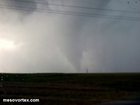
We were deployed on a sorry-looking line of storms when the circulation picked up. The circulation first passed overhead after a supposed area of interest dissipated. As we prepared to turn around a chaser almost ran into us in a hurry to pull off and video something. At that point both Rachel and I noticed what he was recording: a funnel that we watched descend, reach the ground, and grow rapidly. It quickly became hidden in the precipitation which we were sent through to attempt an intercept. The core was devoid of hail but rain curtains made it literally impossible to see past the front of our truck. In addition, the region had received a radar estimated 10 “ of rain the night before, so flooding and water on the roads was a major concern. As we turned east to get onto the road we expected to intercept the tornado on, DOW7 announced to us that their power was out and they were unable to scan, so they had no idea where the tornado was. Thankfully a few minutes later we found out DOW6 was still scanning and the first tornado had dissipated.

As Lindsay and I finally broke through the precipitation, we spotted what appeared to be midlevel circulation which then seemed to evolve into a funnel, then eventually evolved into another tornado. At this point we realized we might need to turn around to deploy pods in its path, and things went a little haywire. Probe teams split up as everyone tried to figure out the best spot to deploy. Based on initial DOW6 guidance, Lindsay and I dropped a pod right on the main road (270), which we then had to pick up quickly as the tornado occluded and reformed on the other side of the road. We then moved to a town called Slapout and went north a few kilometers before receiving instructions to move back south towards where the circulation (no longer visible to us but visible on radar) was crossing.

As we tried to work out pod deployment instructions, Josh came on the radio: “Pod teams, the tornado is now close to the road, you do not have much time.” At this point we were 3 km south of DOW7, and Lindsay starts yelling at me to stop driving, “Stop stop stop we’re already too late, it’s right there.” Josh: “While you’re deploying pods you may get into the circulation; don’t worry, the winds are only 70 or 80 mph, this is a very weak tornado. It will be crossing 4 km south of the DOW in 5 seconds…4…3…2……the tornado is on the road now…ok, the tornado has crossed the road, please continue south.” At this point, I was already laughing out of confusion/frustration at another failed pod deployment, and also at the fact we had a countdown for a tornado that we couldn’t see a kilometer (that’s less than a mile) ahead of us. As I pulled off the side of the road Probe 12 made a horrible wretching noise, and I could tell I was dragging something that was supposed to belong to the car underneath us. I was still surprised from the deployment that had just failed, then became extra surprised by the new development and needing to figure out a not completely muddy location to pull over since the ground was nothing but mush next to the road. Eric came on the radio to tell us we were dragging something under us, and I hopped out to look. Sure enough, the entire driveshaft had fallen off the bottom of our car, a kilometer away from the third tornado. I hurriedly grabbed my cell phone and wallet and jumped into Probe 11 since it was still pouring and operations on the storm were still underway.

Lindsay grabbed her phone and did the same.

So here we sit, passengers in Probe 11 while Eddie limps back to the hotel in Probe 12. Eddie hurried over to take a look at it when they returned to pick up a pod and figured out we could get it to our overnight location (how he did this in the pouring rain, I do not know). He rallied up DOW6 members Justin and Matt and the media member, Yoshi, to do a quick fix. They removed the driveshaft until it can be reattached tomorrow morning and are driving about 3 hours at 60 mph.`

What. A. Day.

Saturday, June 12, 2010

Four tornadoes, Two Days


Deer Trail, CO

Successful deployment on a tornado that lasted longer than 30 seconds by most of VORTEX2, including the UAVs (Unmanned Aerial Vehicles)! Unfortunately due to, once again, a poor road network, tornado pods were not and could not have been deployed. Two tornadoes formed near the same location, but by the time the meso reached the road it was no longer producing tornadoes. After sunset operations were called off and a few anticyclonic* funnels could be seen between lightning strikes, causing DOW7 and another mobile radar to stop and scan. At one point three funnels could be seen at one time.

Post-tornado meso

Limon/Genoa/Arriba/?, CO

This day was very interesting because we almost ran into two (three?) tornadoes. Initially we moved towards a tornado-warned storm in Denver then turned around and decided to target the southern storm near Limon (where we’d been sitting the past few hours). On radar the storm looked nice with a high-reflectivity core and a hook, then it blew up into an HP (high precipitation) mess. The CSWR pod teams were separated so that 15 and 16 followed DOW7 and 11, 12, and 13 took off on our own down a curvy, narrow, dirt road with two media vehicles following us. As we were moving north we got instructions to turn around and move back south to where the circulation was—we’d overshot it. Unfortunately, turning around meant core punching. Within a few seconds of turning around we were taking baseball-sized hail (2+ inches). Baseball hail is interesting for multiple reasons:

1. Its terminal velocity is pretty freaking fast. Imagine someone dropping a baseball from a two-story building and it’s coming at your head. Ok, now instead of a two-story building, that baseball is being dropped from 10 kilometers up in the atmosphere.
2. Baseball sized hail breaks into smaller pieces upon impact. These “small” pieces are the size of golf balls.
3. The microphysics of getting baseball sized hail also means they are few and far between compared with pea or nickel sized hail. So every now and then you just see a giant piece of ice fall in front of you.
4. It’s ice the size of a baseball. This ice actually melted on the way down from the cloud, which means at some point that piece of ice was much larger than a baseball.

Miraculously, we had no major injuries or vehicle damage. 13 has a nice ring of cracked windshield and 11 has a new large crack. Our already super-cracked windshield on 12 received no damage.

Anyway back to the tornado. At this point we can barely see 100 feet in front of us thanks to this wall of precipitation. I was driving, and in addition to being concerned about the hail, I was concerned that the dirt road we were on was getting a bit ruddy; this would not have been the first time a vehicle got stuck in the mud, but we were expecting the tornado to pop up somewhere nearby this time. In fact, it did just that. 13 was leading the pack and from a few cars following distance behind, I saw them hit the brakes and start backing up. Alex got on the radio and shouted frantically “We have a circulation on the road in front of us, we’re turning around, go north!!!” As we all hurriedly tried to turn around in the baseballs on the dirt/mud road, Josh came onto our frequency to say “Did you deploy pods?” Alex: “No we never made it out of the hail to deploy! We’re moving north, the circulation is on the ground in front of us!” Josh: “Don’t turn around, continue moving south. The circulation should be crossing the road now, it’s not that strong, we’re seeing winds of only 80 to 100 mph.” …………….

To recap this deployment: dirt road, baseball-sized hail, oops the tornado is on the road 50 feet in front of us, it’s ok it’s only 100 mph winds, did you deploy?

I’m sure we have very interesting mesonet data.


Driving into core

So we bailed east through the storm, got ahead, then were sent back west towards more dirt roads. We passed by a deployed DOW6 and went in circles on the dirt road network as our instructions changed to get us closer to the meso. We noticed we were getting dangerously close to the core (again), and received instructions to move back east ahead of it (again). As we were all bailing, a tight circulation appeared off to our right which we reported, then a couple minutes later a less tight circulation appeared immediately to the left of the road. Our initial thought was they were both landspouts** and went about our business. Then we received word from DOW6 that it was definitely a tornado associated with the meso; from about half a kilometer away at their lowest scan they had a very pronounced “doughnut hole” on radar at the location we (and they) were visually seeing the circulation.

To recap this deployment: East, west, east, uh oh core, east, landspouts right next to us?, nope more supercell tornadoes.

*Most tornadoes in the northern hemisphere spin counterclockwise, or cyclonically. An accompanying anticyclonic circulation is not uncommon with a cyclonic mesocyclone.
**Landspouts don’t begin in association with the circulation of the mesocyclone, but develop ground circulation along an area of shear (changing wind direction) which is then stretched by an updraft. Landspouts are still tornadoes (people can get into arguments about this), but not the long-lived, damaging types like those that form from a parent mesocyclone. Landspouts can also evolve into traditional supercell tornadoes; the Jarrell, TX beast began as a landspout event.

Tuesday, June 8, 2010

...Intercept?

We had an interesting day yesterday.

After sitting in a park in Kimball, NE for about 4 or 5 hours, we moved north towards Scottsbluff and prepared to deploy on our target storm. At this point we could also see a good number of chasers converging on the area on StormLab (plug for Evan) and I was at least a little concerned about that. We'd already tried to deploy in that area earlier this year and ran up against a poor road network; the addition of more cars pulled over could have made deployments even more difficult. Probe 12 consisted of Lindsay and myself only yesterday, and we pulled over in a parking lot literally next to the Nebraska/Wyoming border on the Wyoming side. We were then sent back into Nebraska to attempt another play on the target storm. It caught up with us again and we were forced to backtrack and continue to move east to get ahead of the storm. At this point DOW6 recorded a decent tornado that was even visible at the lowest tilt of the nearest WSR-88D.

Eventually that storm began dying (because we kill storms) so we had to move back west to go after a new target following immediately behind the first. Our initial concern was that the storm following the first one would be eating the former's dust...literally. If the first storm had eaten up all the good air and then output less desirable air, it would kill the second storm off before it had a chance to produce anything. As we moved back west and then east again (this happens a lot), an interesting turn of events occurred. Operations were about to be called off, teams were making dinner plans amongst themselves, when DOW7 began observing a new area of interest. At the same time, our probes and others began reporting power flashes, a funnel, some debris... and things started getting hectic. Our probes were sent back to 26 to potentially deploy pods along the busy road that was also full of chasers hightailing it away from this unexpected tornado.

Once we got to 26, in the confusion 3 of us moved west towards the storm about half a mile and the others held up at the intersection of 26 and 71, the north-south road DOW7 was deployed on. Josh came over the radio to announce that the tornado was crossing 26 so we wouldn't have an opportunity to deploy pods, but to hurry east (again) to get ahead of it. Unfortunately, the road had a median and 3 of our pod vehicles had to move west towards the "area of interest" before we could get back east.

For Probe 12, this next 30 seconds was very interesting.

I had hopped out to turn on our pod cameras in the back of the truck and when I got back in the vehicle the door ajar light came on. Thinking it was our back door, I hopped out again as other vehicles were fleeing to make sure the back was closed. When I hopped back in, I realized it was my door that was ajar. As I was trying to figure out why, Lindsay moved the vehicle further west to our closest turn-around spot, and we were hit by a very strong wind gust that knocked the antenna on our vehicle off the top and significantly rocked our Dodge Ram. The two vans in our crew were also at the same location, but Probe 12 was the only vehicle with weather instruments.

After the storm became outflow dominant (aka not going to do much from now on), Lindsay and I collected our mesonet data to discover we'd recorded a 50 m/s wind gust at that time. That's over 100 mph. That number is before we subtract our vehicle speed, which was about 30 mph at the time. The people that process the data will do that, and we cannot wait to find out what the post-vehicle moving speed is. The NSSL/PSU mesonets recorded gusts of ~35 m/s with vehicle movement taken out at a nearby location, about 70 mph. These values were recorded while DOW7 was recording a weak tornado a few kilometers southwest of its location.

That all being said, we're not exactly sure of our location. A few of us wonder if we were in the outer circulation of the tornado and will make that our story until the data tell us otherwise. :) More likely is that we were in some very strong outflow as the gust front passed through. Initially Karen said we should have been east of the storm when they sent us that direction so we shouldn't have been near the circulation, but once we explained that a few of us went west instead of east she said, "...Ohhhh"... but still figures we were safely out of the way. Nonetheless, it was a very exciting experience, especially given our not so interesting experiences from the rest of the project. If nothing else I'm happy that our probe was able to add to the other mobile mesonet data along that transect since no one really expected anything to happen at that point, so this case will be interesting to put back together to figure out what happened and how.

Wednesday, June 2, 2010

A New Hope


Dimmitt, TX 1995. Happy 15th Anniversary, VORTEX.

VORTEX2 implemented a new strategy today, 15 years to the day from the VORTEX (1)-saving tornado in Dimmit, TX. The final week or so of the original two-year VORTEX project was a Godsend to the program. Perhaps in honor of that blessed day, from now on we will no longer have 10:45 A.M. CST (or is it CDT right now?) general weather briefings. Instead, the PI (Principal Investigator) meeting will take place earlier in the morning and we will depart shortly thereafter, forecasting on the road like many amateur/professional chasers do. The idea is that this will allow us to pursue more distant targets that we might otherwise give up on. So far giving up on the distant target has, pardon my language, screwed us over at least two notable times while we watched in frustration from (both times) North Platte, NE. Remember the large wedge in South Dakota a couple weeks ago? "Too far away." The photogenic tornado in southeast Colorado a few days ago? "Unreasonable travel distance."

South Dakota, 5/22/10 (examiner.com)

Campo, CO, Memoral Day (stormbruiser.com)

After these two iconic misses, the PI's have decided that we need to increase travel and decrease sleep for these last two weeks. I don't blame them; I wondered early on this year why we waited to leave until noon on days when we knew our target would be a great distance away. We've also not had another Goshen County, WY storm this year. That storm capped off the worst tornado season on record, and perhaps spoiled us a bit for this year. A lot of us (I know from personal parking lot discussions) expected Goshen County every week this year. We thought, "Hey, last year sucked because the weather sucked and there was nothing we could do. Now we'll be on every storm, in the right place, getting tons of data all the time!" Of course, with two weeks left in the project, crew morale has waned and everyone is getting a little desperate.

Hence the new strategy, or the new hope, if you're feeling optimistic and a little nerdy. My personal hope is just that our fearless leaders remember we're humans, not droids. We laugh, we cry, we actually lose a hand if you cut it off with a lightsaber. The Force that guides us also tells us to go to bed sometimes. We wish the character Jar Jar Binks had never been introduced to the series too.

Ok killing the analogy...now. Anyway, I for one will be consuming more caffeine than perhaps even during finals these next two weeks, and my exercise schedule went out the window (wait, did I say "schedule?" I meant "attempts to exercise depending on how long I am allotted to sleep each night"). I hope I have renewed your interest in the blog by putting in other people's tornado pictures today. I sure wish I had seen them and/or collected data on them too.

P.S. Day 1 of the new strategy did not result in a successful deployment. But we have driven about 1100 miles in the past two days!

Tuesday, June 1, 2010

Moderate Risk Today


Probe 12 in all its malfunctioning glory against sunset mammatus after last Wednesday's storm.


I apologize for the lack of updates. The past 3 or 4 days have either been down or travel. After our last big chase in between two states, CSWR stayed in Boulder while the rest of the crew was in Loveland, CO to do DOW repairs and maintenance. We then drove 4 hours north into South Dakota to then drive 4 hours south the next day. We also had a chase day in Colorado that resulted in a pretty supercell that was not quite able to get its circulation to the ground. My vehicle also continued to break, and Justin had to replace the battery. Yesterday in Colorado a rather unexpected tornado occurred that would have been perfect for deployment. The ingredients didn't seem altogether for tornadoes, but what is called "high plains magic" came through. Now we are somewhat hopeful with a "Moderate Risk" outlook in the region and are awaiting further instruction!

On a personal note, Matt and I celebrated our first anniversary May 28th. We met last year on V2, so this project means a little something extra for us. :)

Wednesday, May 26, 2010

Brief Updates

Hello all,

I apologize for the lack of updates lately, but nothing's really been all that interesting. We stopped at the Twister museum on a ferry day, had what I consider our first legitimate down day on the same day there was a tornado outbreak in South Dakota, drove the same stretch between Sutherland and Ogallala, Nebraska literally 8 times in 50 knot winds, and today we were once again deployed north of a storm that produced multiple tornadoes, another casualty of miscommunication.

My last enttry resulted in more controversy than I'd expected, and I had over 100 hits the day I posted it (I average around 25/day). Regardless of your opinion of the post, I thank you for stopping by, reading, and contributing your thoughts. I'd like to stress that this is my personal blog, and therefore the thoughts I express here are nothing but my own personal take or opinion on a situation. Just like anything, VORTEX2 is made up of individuals, and we all have our own feelings that may either support or differ from that of the collective group. I hope what you take away from these posts are points to ponder and the thoughts of someone that does not have to put out well-thought-out PR statements. With that said, I'd appreciate it if no one posted personal attacks against myself or others in the comments section; I do welcome healthy discussions though.

On a more personal note, my apologies to family and friends I've not had a chance to talk to recently. Even though nothing too interesting (on my end) is happening, we still keep long hours. I am literally just now pulling into the hotel tonight. Hopefully more exciting updates soon!

Friday, May 21, 2010

A note on chaser convergence

Chaser convergence 5/19/10 (Source: J.R. Hehnly via Patrick Marsh)

Today has been a PR nightmare for VORTEX2. A video, which I will not link here, surfaced of the TIV (Tornado Intercept Vehicle) and its follow vehicles/Discovery Channel presumably passing on a blind hill during Wednesday's massive chaser convergence. This coincided with a somewhat heated beginning to the morning weather briefing, at which Josh Wurman expressed all our frustration with the chaser convergence (see picture). He also made a public statement through The Weather Channel, which in addition to the video has people across the chasing community/internet all in a flurry. Here are my thoughts on Wednesday's chase, the result, and the ongoing aftermath:

1. As you can tell from the photographs, it was physically impossible for VORTEX2 to complete its mission on Wednesday. Our mission necessitates that we be ahead of the storm, while the mission of most of the other chasers is to remain almost parallel to (or on Wednesday, underneath) the mesocyclone. Once 33 turned into a parking lot, mobile mesonet vehicles were unable to complete transects in crucial portions of the storm, the mobile radars were unable to maintain leapfrogging dual-Doppler lobes, and pod deployment teams (me) could not get ahead of the rain-wrapped tornado that was on the ground to deploy our instruments.

2. Amateur and "professional" (whatever that means in this instance) chasers have just as much right to be on the roads as VORTEX2 does. It is a free country, and God bless America you can go pretty much wherever you darn well please. That being said...please let us through. This is not a selfish request. We have one overarching goal: to improve the science of tornado forecasting/understanding. By better understanding tornadic supercells and other storms we can increase forecast times and hopefully save lives. The "save lives" creed might sound trite and overused, but it's the reason we are out here. With literally hundreds of vehicles on the road, things can get dangerous really quickly for all of us, and the "save lives" issue becomes much more immediate. If you are in chase mode, please be the same safe and courteous driver I know you normally are.

3. Sean Casey and the TIV have worked closely with Josh Wurman and CSWR over the years, but the TIV and its follow vehicles are not affiliated with VORTEX2 in any way, shape, or form. The CSWR decals on their vehicles that everyone has pointed out in the chaser video have ended up there from years past while on "Storm Chasers," and do not belong there for this project.

4. Josh Wurman's comments to The Weather Channel probably come off strong to a lot of people and may even infuriate some chasers...but that's just Josh. I think a lot of the backlash at Josh comes from the belief that he's being hypocritical after the TIV video surfaced, but let me reiterate: the TIV is not part of VORTEX2.

I really want to stress that I am not saying the 1147 other chasers on Wednesday's storm had no right to be there: free country, etc. I am pleading, however, for cooperation from the chasing community. I've seen threats to intentionally sabotage the V2 mission in internet comments from chasers, and I shudder to think of the implications those threats have. In addition to making all but last year's Goshen County, WY deployment failures, intentional sabotage of the V2 mission sends the message of "I care more that I am offended at a request to pull over for 30 seconds than I do about the fact that this project is designed to improve life not only for myself and my family, but for all those living with the threat of severe weather." That attitude is frightening to me.

/soapbox

On a happier note, I want to thank those chasers that were truly helpful to our mission on Wednesday. One in particular stopped our probes from going down a dirt road with a bridge out at the end as precipitation made its way towards us. Another saw our probe trying to turn left onto 33 and stopped traffic to let us through. The V2 teams are definitely not the best thing since sliced bread, but it's really uplifting to see support in the field. Thank you to everyone that supports our mission!

Wednesday, May 19, 2010

Success!

Tornado visual, finally!

The VORTEX2 crew had a very successful deployment today on a slow-moving HP (high precipitation) supercell in the Texas panhandle in and around Dumas! Teams gathered data on multiple tornadoes spawned by this beast of a storm which had an extensive hail core approaching 80 dBZ! We shared the road with literally HUNDREDS of amateur chasers in a region with a subpar road network, which resulted in traffic for miles along rural farm-to-market roads. After most teams got stuck to the point they could no longer get ahead of the storm, official V2 operations were called off. The CSWR crew, however, had already fled to the south then east then north as most teams observed the (as of current knowledge) longest-lived tornado produced by that storm. Many of those teams also got damaged by hail, however, and CSWR was able to pull off a final nighttime deployment which included (essentially) blind pod deployments. Because it was dark the pod teams had no visual on the tornado, so we completely relied on DOW-7 and DOW-6 to keep us away from the tornado that Josh was observing from the radar.

Our crew did have the earliest sighting of a tornado from the storm, however, as we fled south from an area that was starting to receive heavy precipitation as the rotation became rain-wrapped. The tornado touched down for a few seconds before retreating. Prior to that I also had visual on a very brief rope-like protrusion from the rotation, but in my excitement I didn't get any photos of it--this is a shame because it sounds like most people did not notice this feature, so I may never know if it was a figment of my imagination. At our second location the rotation of the mesocyclone was still very broad with a beautiful green color in the center due to the large hail. As we were standing under it Tim Marshall called in a report of a multiple-vortex tornado that the rest of us did not have visual on. Due to this and another called-in report of a funnel cloud, we were told to deploy pods in 70 mph westerly winds...not only was this a waste of resources, but my clothes are still wet.

As skies turn green.

During our ferry away from the hail core/tornado? the storm "cycled" and produced a new meso with a much less broad wall cloud. We continued moving to get ahead of the storm as the longer-lasting tornado was reported, leaving the amateur chasers in the dust (with baseball-sized hail). Then, with only CSWR left behind, we prepared for our own tornado-scale deployment, which was fairly successful in and of itself.

Massive core

Tomorrow looks to be another big day!

I've also filled up a photo album, check it out!

Sunday, May 16, 2010

New Mexico


New Mexico

Today we got back to killing storms. We drove all day to a little town called Artesia, New Mexico, inconveniently located between the awesomeness of Carlsbad caverns and Roswell ('nuff said). There we hung out on a playground for an hour or so that was across from an oil refinery, so we breathed in potentially dangerous fumes while running around. Curiously this refinery was across from not only a playground/park, but an elementary school and an animal shelter as well. We entertained ourselves by writing equations on the back of Probe 11. I then literally fell asleep in the backseat of Probe 12 during our "chase" of an unimpressive cell west of Artesia. We then celebrated the death of another storm during VORTEX (dubbed by Jeff Frame the Verification of Ordinary Rain in Thunderstorms EXperiment).
Take that, healthy storm!

Friday, May 14, 2010

One for three

Updates on the past three significant deployments:

Monday May 10th: Outbreak

The outbreak on Monday in Oklahoma resulted in a lot of damage and a few fatalities. As I mentioned in my previous post, no DOW data was collected on any of those storms nor did any of the CSWR crew have a visual. The most poignant thing we encountered was the damage path of the storm; a humbling experience for everyone.


Paul Markowski, this week's mission scientist, explains the plan for Monday's deployment. The multiple circles show different mobile radars' coverage areas. The coverage areas where two radars overlap are dual-Doppler "lobes."

Wednesday May 12th: Dual-Doppler Tornadogenesis

The first (almost) fully-successful tornado deployment of V2 2010. We got dual-Doppler (dual-polarization) tornadogenesis on a short-lived tornado near Clinton, OK. As far as I know no one on V2 had visual on the actual tornado, but a nearby chaser did. Our probes almost got "cored" (slammed by hail) and were sent quite a distance from the storm which prevented any pod deployments as well. The dual-Doppler tornadogenesis, however, is quite a dataset to celebrate! VORTEX stands for Verification of the Origins of Rotation in Tornadoes EXperiment, so data on the tornado as it is still developing is valuable for the purposes of the field project. Dual-Doppler lobes are also an important aim of the 10 mobile radars, because from these overlapping areas we can interpolate the three dimensional wind field. A single radar on its own only "sees" the two dimensional wind field, from which we can only estimate certain features. This is also the first time this has been done with dual-polarization data (see earlier post for an explanation).


Before the storm became tornadic and after the probe teams high-tailed it from the hail core.

Friday May 14th: Hail and another missed opportunity

Today we moved west in Texas only to have a tornado happen during lunch. We knew this would be an early show, but despite our efforts we were still out of position by about 20 miles (again). Most teams had visual on today's TWO tornadoes, but the CSWR crew was neither in position for data collection nor for a visual. Early word on the street is that some other teams did get good data, so that is good news for the project. Otherwise we saw some good lightning and took some nice hail that was then taken from the side of the road and put into our cooler in lieu of ice.


Hail from the core of the storm that was tornadic. The hail we took a few minutes later was a bit smaller.
__________________

So far the CSWR crew is 1 for 3 for successful tornado deployments and 0 for 3 for visual on the tornadoes. The next two days look to be operations days as well. On the bright side, we did get to stay in a Hilton hotel last night.

Tuesday, May 11, 2010

Thoughts and Prayers

The CSWR V2 team did not see any tornadoes today, nor did we collect any meaningful data. As we drove to a nearby powerless hotel through devastated communities, our dismay became even more tangible. The positioning of hundreds of people and instruments is a difficult task, and unfortunately in this instance my crew was in a bad place.while I am disappointed we did not have a visual on this monstrous storm, I am most disappointed that no DOW data was collected. Tthe destruction that we are currently located near is devastating, and we cannot even find solace in being able to learn something from it. Please keep these communities in your thoughts and prayers.

Sunday, May 9, 2010

Mother's Day


Happy Mother's Day! This morning kicked off with scattered phone calls to VORTEX2 mamas; the number of phone calls increased exponentially after the weather briefing when Herb made an announcement. A lot of people were at the weather briefing today in anticipation for Monday's play. After learning today would be a travel day to position us for Monday, Herb gave a short speech to everyone that essentially went: "I know we all get a bit busy out here, but everyone needs to remember to call their mothers today. Do we have any mothers in the room?" A few women raised their hands and we all clapped. A cute start to the day.

Afterwards the probes were released to position ourselves for Monday's play, and we had about a 5 hour drive to our destination. A few of us walked to dinner (half a mile away) then got caught literally running back to the hotel in pea-sized hail and lightning. We'll be getting up early tomorrow to check pods, instruments, and our vehicles in general before what promises to be a big chase day. The current SPC outlook calls for a moderate risk of severe storms and has strongly worded discussions like "Supercells with strong tornadoes and very large hail are expected Monday."

"Probability of severe weather within 25 miles of a point.
Hatched Area: 10% or greater probability of significant severe within 25 miles of a point.
A significant event includes any of the following:
  • Tornadoes rated EF2 or greater,
  • Thunderstorm Wind Gusts at 65 kt or higher,
  • Hail 2 inches or larger in diameter"
  • (SPC)

    Wish us luck and safety....

    Saturday, May 8, 2010

    First deployment and other travels


    The first official deployment of VORTEX2 2010 was yesterday in northwestern Kansas near sunset. I wish I could offer exciting news about the deployment, but honestly I didn’t even take any pictures of the storm early on due to a very unattractive stratus cloud deck blocking our view of any defining features.

    First let me back up a little. We ferried from Dodge City, KS to Clinton, OK and then back up to Woodward, KS a few days ago, presumably for the sake of driving around. In Woodward we reunited with the rest of the V2 crew before ferrying to Hays, KS, docking point for DOW missions in the pre-V2 days. Yesterday morning we had two options for deployments: northwestern Kansas (close to our location in Hays) or eastern Kansas. The first option gave us a chance to play off the triple point while eastern Kansas provided better moisture along the warm front. Most storms were unlikely to initiate until almost sunset or after, so the steering committee finally decided on the northwestern Kansas target so that daylight might play in our favor.


    The mission began (at least on the radar frequency) mostly as a practice deployment for the instruments, particularly the radars. The cell we were casually eyeing became supercellular so we began moving towards it and were given instructions for a hasty deployment…in dime-sized hail. I’d like to say things went smoothly, but basically the mission was a chance to show everyone what we were doing wrong. As all the probes collected our mesonet, pod, camera, and GPS data on the way home we had a host of issues that still have not been completely resolved. We have an early morning meeting tomorrow to review all probe teams’ data. News I’ve heard from other non-CSWR teams includes 3 vehicles getting stuck in the mud, which could be a first for earliest stuck-in-the-mud vehicle in a season (we’re only a week in!).

    So that small mission has been interspersed with more down-ish time. While awaiting instructions yesterday a few of us worked on papers and a couple hours later we had our first sketchy bathroom stop during the mission. This year we have more girls, so it was a kick to watch everyone’s reaction as a group to the outhouse/hole in the ground. Last night we were also privy to some major winds at the hotel thanks to nearby severe storms. There was a single tornado report yesterday in eastern Kansas, but it occurred in the dark when we would not have deployed. While ferrying today we stopped at the Montezuma wind farm south of Dodge City, KS and got some really neat pictures of DOW-7 right next to a turbine. The visit inspired me to work more on the wind farm paper I’m in the process of editing, because that’s one of the locations we discuss in the paper! I’m writing now from the back of Probe 12 as we move south to position for a potential Sunday mission, but Monday looks to be a really big day….

    Wednesday, May 5, 2010

    V2 Reunions and (E)F5 Rememberance


    We got the heck out of Dodge (City, KS) on Sunday, a day on which everyone was afraid they'd missed Mother's Day. Most of CSWR stayed to work on the DOWs and other vehicle problems until later in the evening, but a group of 6 of us left early to do a little local sightseeing at Fort Supply Lake on our way to Clinton, OK. Clouds overtook us, however, and we were almost constantly "virga bombed" the rest of the way to our hotel. Basically it got very windy quite suddenly multiple times between our dinner stop in Woodward, OK and our final destination.

    We turned right back around the next day and moved to a place we'd passed through, awaiting the rest of the V2 gang. While waiting we went into a 90 degree F pool and swam around for over an hour, then all piled into the van again to bring 10 people to a local BBQ joint. As we left the BBQ joint, we passed a bunch of the other PI's and some of our friends from other crews--dinner options in town were limited, and the word spread that this place was good. From there we moved to Dairy Queen where we overwhelmed the high schoolers working there; they did a fast job nonetheless. Then last night we went to the hotel bar and hung out, played some pool, and caught up with some friends from other groups. Laundry was also done.


    Hanging out...again (Photo: Andrew Arnold)

    This morning was the first day I had a chance to exercise (yay!) so I got up early to do that. From there I went straight to the continental breakfast (which was excellent) and caught up with even more friends from last year. The all-hands V2 meeting was today! We got briefed on safety issues by Josh and were reminded that a lot of PI's are miked for Discovery/The Weather Channel/NHK/??? so to keep our conversations professional. It is very odd to be involved with a reality show while doing science...we showed up at the hotel yesterday to have one of the crews run over and put boom mics over us while we were cutting up in the parking lot.

    Today became another down day which involved sitting in the sun, catered lunch, a probe vehicles meeting to review procedures, dinner at the hotel restaurant, and some television-watching at the end of the day. The internet access has been horrible! This happened quite often last year when over 100 of us swooped in on a single hotel; I am concerned because I have grades to submit this week. Looks like tomorrow is a travel day with potential for marginal operations on Thursday.

    It would also be remiss of me to not mention that Monday was the 11th anniversary of the 5/3/99 Moore, Oklahoma F5 tornado, and Tuesday was the 3rd anniversary of the 5/4/07 Greensburg, KS EF5 tornado. These events are significant together: the Greensburg storm was the first tornado since the Moore event to be given the (E)F5 ranking, an eight year time span. Almost a year later the Parkersburg, IA storm was the next and most recent storm (in the United States) to be classified EF5. The Manitoba tornado in Canada also received an EF5 ranking in 2007. It is important to realize these events, without "direct" measurements like those obtained by mobile radars/tornado pods/the TIV, are classified based on damage surveys conducted after the event and may not necessarily be representative of the true maximum low-level wind speed of the tornado. More on this later... ;)

    Sunday, May 2, 2010

    Down Days


    Prepping for departure from Boulder.

    Not much to report the past couple days. We finally left Boulder on Friday and headed into Kansas. Yesterday was the first official day of VORTEX2 2010 (yay!) but prospects looked poor for at least a couple days. We moved again yesterday and spent the afternoon working in the parking lot. First we went to Applebee's, which required more unconventional seating methods.... After helping outside (see picture) we got cleaned up and went to a casino for dinner and some slot machines. Nobody walked out ahead.

    Helping in the parking lot. (Photo: Tim Marshall)

    Today we're ferrying again to hopefully meet up with the rest of V2 (finally!). The probes are leaving before the DOWs so we plan on stopping at a lake on the way to get a little sun. Hopefully more fun updates soon!

    Friday, April 30, 2010

    Dashing Through the Snow


    We awoke to snow this morning. That's right, we kicked off the second phase of the largest tornado study in history with a little winter precipitation. The mountains were beautiful and the 8-year old in me that gets excited to see snow perked up, but I did not waste suitcase space packing long-sleeved shirts. I have t-shirts and a North Face fleece. Today was a very cold day.

    That was the most exciting thing that happened today, and I have some beautiful mountain pictures I'll upload later. Despite an early morning at the hangar I spent most of the day working on odds and ends: filling up containers with diesel fuel, tightening cables up in probe vehicles, buying large folding tables at Home Depot, and kicking off catering with a fun trip to Safeway. Lindsay and I had been through catering last year, but Erin and Mareike (a student from Germany who is in the States for her first time) were along for the ride. We buy enough food for ~34 people (much less today) to make their own sandwiches and have chips, cookies (Oreos...there always has to be Oreos), a veggie platter, fruit, hummus, yogurt...and anything the team in charge of buying groceries that day feels like throwing into the mix. This can be helpful on chase days to avoid long lines with 100 people waiting for McDonald's, but also involves a lot of planning and time setting up and taking down tables and food. Our crew today did a good job; we received many compliments on our food choices!

    Because we are working in a hangar at an airport, the inevitable happened today. A brand new airplane had to be hauled out of the hangar and tested in the parking lot. That cut into a bit of our work time today as we moved materials out of the plane's path and watched the owner experiment with it. A media crew from Japan is also following us for a week or so again this year. As I remember, they were out with us last year and the whole stormchasing concept was intriguing to the foreign audience, so it appears they've returned. Yesterday I explained to a man and a woman translating for him what purpose each mesonet instrument served and gave a little background on the different radars and other odds and ends about the project. They were enthusiastic and so was I, which always makes for good conversation.


    My dad is a pilot so I was not as excited about taking pictures of the plane as everyone else. This shot courtesy of Matt.

    We were released fairly early tonight and a large group went to a pub right outside the hotel for dinner. There was a good band and good food, but we all were ready to call it an early night with the expectation of a long day tomorrow. Eric has also come down with something and was quarantined earlier today; he ventured out for dinner and tried to talk to Matt and me at our three person table (very odd set-up for an 11-person group) but still has a very sore throat. Hopefully a day of rest has done him well; we'll be returning to the hangar at 9 a.m. tomorrow.

    Thursday, April 29, 2010

    Hanging at the Hangar


    A view from the CSWR hangar in Boulder, CO

    Greetings from Boulder, Colorado! We’ve spent Monday and Tuesday at the CSWR hangar prepping vehicles and instruments. A lot of radars (ours and other V2 groups) have been upgraded to dual-polarization, a long, expensive process. Dual-pol is scientifically valuable for multiple reasons, including the identification of microphysical cloud components. We can get a lot of information from identifying which parts of a storm are ice crystals versus water droplets versus very unfortunate bugs. In tornado research, this information is also invaluable in discerning debris from the actual tornado.


    How a vertical cross-section of a storm appears in dual-pol radar. The top is the usually-seen reflectivity, and the bottom is the composition of the storm. All the white in the front? Bugs. Sorry bugs.

    Although this information is valuable, the upgrade process involves many man-hours (or woman-hours), and quite often a large dose of frustration. We were at the hangar until midnight MST Tuesday night (2 a.m. EST) and some of the crew was up later than that. As of today the CSWR radars are still under construction/testing. The change to dual-pol also lowered our clearance for driving underneath bridges/overpasses/low-hanging trees, so we may incorporate a “scout” vehicle this year. Essentially we’ll be sending a vehicle we already have ahead of the radars along the same road to determine if there’s enough clearance. Because they are dual-pol, we also cannot have the protective radomes over the antennas anymore. Radomes are covers for the radar dish that protect the antenna and dish from debris, small hail, etc. Not sure at this point how or if this will impact operations for all the radar teams on V2 with respect to their locations in the storm environment.


    Around midnight EST at the hangar.

    Aside from the radars (essentially the stars of the entire project), I have personally spent a lot of time working on pods for the probe vehicles. CSWR has 6 probe vehicles: 4 of which have 3 pods and mobile mesonets, and 2 of which have 2 pods and no mobile mesonets. Both the pods and the mobile mesonets collect the same type of data: temperature, dew point, wind speed and direction. The pods are deployed near the tornado in hopes of getting near-tornado data. The probes have instruments attached to them and drive in the storm and near-storm environment to collect the same type of data—this is when a probe becomes a mobile mesonet.


    Working on pods in the back of a probe. Got it? :)

    I got a refresher on pods yesterday and then spent today showing some new members how to use them and working on some general issues with Erin. In addition to the instruments we have HD video cameras pointing different directions on the pods. Those have been difficult to attach and maintain in the correct direction on the pods. They also operate when the display is facing outwards, so we’ve been playing around with different solutions to that problem. After doing and undoing a few things we settled on gluing plexiglass over the display, which required cutting a large sheet into smaller pieces and shaving down the edges first.


    All of this should give you an idea of how the past few days have gone. Experimenting with ideas, finding out they don’t work, trying other ideas. Testing something, finding out it didn’t work, thinking it works, testing it again. Matt, Jacob, and Eric (henceforth: “the guys”) spent a lot of time wiring vehicles and handling software issues the past couple days. It’s all fun but tiring. Errands away from the hangar involve getting food and supplies for everyone, and often require unconventional seating methods….


    DOW Van...so we meet again....

    The IMAX crew for Sean Casey’s TIV (Tornado Intercept Vehicle) team has also been shooting scenes. At $1000 a minute for film, it’s very important to not interrupt their shots. Yesterday they had us do a time-lapse shot in which they take 2 minutes of footage that will result in less than 20 seconds of actual film time. We carried all 16 pods out of the hangar and then back in. By the way…each pod weighs 120 pounds. My arms, legs, and glutes are SORE! Did you know: IMAX film has to shoot image and sound separately? I’ll explain more on that later. Discovery has also been around filming; in the hangar they mostly like shots where Josh is talking to people. This makes explaining things that are going wrong that much more awkward. Both groups had us all sign waiver forms yesterday then packed up and left today. They’ll be back once V2 really kicks off.


    The TIV last year in...Hot Springs, SD, I believe.

    We are expected at the hangar at 9 a.m. tomorrow for more preparations; we may be hitting the road soon. There is a good time period for deployments over the next week, so the start of this season is already looking much more promising than last season.

    P.S. I expect to put on weight during this season of poor food options and horrible eating schedules. Today, however, I jumped out of vehicle to literally have my pants fall down significantly below my hips. Haha!

    Sunday, April 25, 2010

    Packing

    The CSWR crew reunites in Boulder tomorrow! Now that I'm finally caught up on school work, I've been hurrying to clean and pack. Here is the end result of my carry-on:


    Inside you will find:
    11 shirts that will be worn on the regular, slept in, or exercised in
    2 shirts that look a bit nicer
    2 pairs of jeans
    1 pair of khaki shorts
    1 pair of capris
    10 pairs of socks
    13 undergarments
    1 hair dryer
    1 pair of Rainbow flip flops
    1 pair of long workout pants
    1 pair of workout shorts
    3 sports bras

    This single carry-on has to last me 8 weeks! Also, I'm a female, so scientist or not I don't like having such limited wardrobe options. ;)

    I'm also bringing along a roomy messenger bag for my netbook, camera, tripod, a notebook, water bottle, wallet, keys, an assortment of cords for devices...and I think that's all. It's a bit heavy, but mostly it's just a bag to have on my person during the day. It may house some snack food eventually. I decided to bring a folding tripod this year that folds to < 10" and extends to > 40". I may not have the time to use it, but if I do it will make for much better image and video quality.


    I played around with it a bit today and it's really intuitive and fast to use, so I'm excited about it. If nothing else it's useful for self- or group photos!

    Saturday, April 3, 2010

    4 Week Countdown!


    Greetings everybody! With one month to go until the official start of VORTEX2 2010 (May 1st), I thought I'd get things updated once more. When we last left our scientists, we'd had a single successful tornado intercept in Goshen County, Wyoming on June 5, 2009. We got an EF-scale rating of EF-2 thanks to the DOWs and the TIV. There was also major windshield damage done to a couple mobile mesonets. For some good images and review (in addition to my own!), go here: http://www.crh.noaa.gov/news/display_cmsstory.php?wfo=cys&storyid=28445&

    Hopefully we will have many more storms like Goshen this year! No one was hurt, only minor damage, etc. The CSWR crew meets up in Boulder, CO on April 26th, and I have a million things to do in West Lafayette before then. Research-wise, I am working on submitting two papers to two different academic journals in addition to getting preliminary results done for my regular research. One paper is coming from my undergraduate research where we looked at mesoscale convective systems in West Africa as they make the land-ocean transition; these storms can then develop into tropical storms. We will hopefully have that submitted to Monthly Weather Review before I leave for Vortex. The other paper I'm working on came out of a mini field project associated with my fall 2009 radar meteorology class at Purdue. We were given DOW7 for a month and were given the freedom to do whatever we wanted with it (almost). My team of students and a friend's team of students decided to determine the impact of a local wind farm on DOW observations of clear air and precipitation. We got some interesting results that we'll be submitting to the Bulletin of the American Meteorological Society (BAMS) by the end of this summer at the latest. As for my day-to-day research, I'm using a combination of DOW and WSR-88D radar data to investigate tornadic wind speeds. I'll leave it at that for now... ;)


    Looking at DOW scans in SoloII

    That is what I will leave you with for a few more weeks. Until then, be sure to check out these websites:

    My YouTube
    http://www.youtube.com/user/MetNightOwl

    Matt's blog
    http://rydzblog.com/

    VORTEX2 page
    http://vortex2.org/home/